sunnuntai 17. toukokuuta 2009

Day 8: Friday May 15 2009

ENDANGERED SITES: A REOCCURRING THEME
(BUT LUCKILY HIRVI IS WATCHING OVER US!!)

Today at The Thing, excavation on the Geological trenches resumed.

The Sand Pit Wall was as exciting as ever, more of the stratigraphy was cleaned up for mapping. Lead by Andre, students took points in the beginning processes of map creation.


More mapping was done on the South wall of the SPW- this time from the top! A top view map was painstaikingly created by Brenden and Katie of the large organic mass that sits at the bottom of the storage pit discovered earlier this week. Unfortunately because of the time-consuming detail of this type of hand drawn map, it was not done to completion, but not to worry, there's always Monday!


The Survey team (Greg, Dustin, Mike, Loretta, Sabi, Lisa, Max, and Colin) explored the 60 meter contour today with the aid of their handheld GPS unit. They walked along the contour just North of the row house depressions that were found on the second day of Survey (Day 5: Tuesday). Unfortunately today provided negative results for those particular transects. But one cannot forget: negative results are just as informative as positive results, all the information is necessary.

As opposed to the usual Makkara Wednesday, turn of events pushed it back until today. All of the teams gathered at the Kierikki Museum's reconstructed row house for the traditional weekly Makkara lunch around the campfire!!

It is not only a good morale booster in the middle of what is usually a very cold and wet week, but it is also a traditional experience that everyone visiting Finland should have! Even our vegetarian team members enjoyed soy Makkara!

It may also seem as fate had more in store for the team, as they quickly jumped up to help one of the museum's workers. This young man was painstaikingly rolling a very large log (by himself!) along the boardwalk in front of the reconstruction, removing each of the small logs in succession and replacing it in the front of the line.... slow going if you can imagine! You may ask yourself what he was doing dragging this immense log across a beach- he was building a new row house reconstruction... BY HIMSELF!!!

So after a quite relaxing lunch on the beach we were headed on a tour of two sites. The first of which was an impressive site (the one reffered to earlier) which Andre explained may either be three small dwelling structures, or one very massive one all lined in the East-West orientation. This correlates to almost all dwelling structures found in this area.

Then the whole team headed over to the site we would begin work on for Monday, an endangered area already disturbed greatly by logging. On the way we saw two Hirvi, or moose, good omens according to Andre (backed up by early Finnish mythology!!)!!!

The team split up and scoured the ground for scatters of artifacts on the surface and depressions which were in all stages of disturbance. The surface finds were marked for further investigations that would resume on Monday, and the team headed home.
Day 7: Thursday May 14 2009

COMPLICATED STRATIGRAPHY: WHERE PREHISTORIC AND MODERN PITS COLLIDE!!

Today at The Thing was quite interesting and eventful as usual. What started yesterday as a systematic look at the stratigraphy of a bulldozer cut that had dangerously encroached upon a known Neolithic pit, turned into a much intriguing view into what was a surprisingly large and possible storage pit. As we cleaned up the unearthed sand pit wall, this continued into another much larger pit with multiple horizons which had been truncated by said bulldozer. This work was done mostly by Dr. Andre Costopoulos and Max, one of our NOCUSO students.

One of the most imperative goals of today near this endangered site was to map the stratagraphic profile that had been unearthed by the modern cut. By this analysis, we discovered that this looks like a case of multiple disturbances of the area over the long period of time since its original usage. Straight lines seem to dissect the original stratigraphy of the pits, even earlier than the modern bulldozed sections. The mapping was initiated by Katie Grundtisch and Elizabeth Gohringer, who completed the first two meters of mapping in of the 475cm cut into the sand pit wall.

Most likely, as is tradition in this area, large areas of earth are moved and\or sifted for gravel in roads, construction, or what-have-you. This seems also to be the case for the adjacent water-drainage trench which has grown exponentially in size since last years excavations.

Jenn and Beth continued their soil sampling grid in the area of The Thing. They also took some samples near the known Neolithic depression and discovered what seems to be a long period of occupation indicated by complex stratigraphy and plenty of charcoal!

Sam, as well as periodically supervising the area of the Sand Pit Wall, walked the forest; mapping the terrain with the incredibly accurate GPS unit. This unit is accurate to 1cm, acting along with the GPS base station anchored to the roof of the Kierikki Stone Age Museum, which feeds of multiple satellites, allowing for such accurate results.

Today the Survey team systematically scoured the 60 meter contour which entailed a what would have been peninsula and a few small islands in prehistory. They reached an unpassable river but fortunately for them they came across a small fishihng wier which acted like a dam as well as a bridge across the expansive and swiftly moving river.

As well as an exciting moose spotting, the Survey team took a field trip to Haukipudas! What they found there were very large and very deep depressions on the 45 meter contour.
Day 6: Wednesday May 13 2009

DISCOVERY OF A TRAGIC TRUTH: NEAR DESTRUCTION OF A PREHISTORIC SITE

Today, while the team working at The Thing was opening up two new Geological trenches, Andre was checking out a nearby known Neolithic dwelling depression by the side of the road.


To everyone's dismay, he discovered that a sand pit that had been dug in years past for road gravel was encroaching dangerously near to this depression.

So what he has had us do is clean up the stratigraphy in the cut that was made by the bulldozer. This was done in order to see if it had actually destroyed part of the site.

And what do we find? A storage pit had been partially removed and we could see the large organic mass that was formerly the contents of the pit. We do not know yet what it is, we have to wait to remove it. Andre wants to take it out in one large chunk and transport it to the lab so it can properly be analyzed. A possibility is to use apoxi and do thin slices to be viewed under the microscope!!!! (Which by the way is really freaking cool!) Now this is so interesting because: we normally would not see these things from this angle, in an excavation one would be removing very carefully, very slowly, and very evenly in flat layers from the top. Right now, we have a huge in-tact storage pit sticking out from the side of a wall. Nuts!
Day 5: Tuesday May 12 2009

SURVEY: OVERCOMING OBSTACLES

Greg's Survey team covered a lot of ground today; tromping through the forest we were looking for depressions in the ground along the contour lines. This is done because as time goes on in the geologic history of this area, the land uplifts, so you can see distinct shorelines for particular points in time, they appear as ridges (contours) that dramatically drop off in elevation. This means that as the land was rising out of the ocean, people could only inhabit what was above the water. And where do people like to live? By water! For transportation, food, etc. So these ares, by the old shorelines and rivers, are the best places to survey. Good indications of human occupation are dwelling depressions and storage pits; these depressions look like distinct holes in the ground, unlike many other types of holes that occur in the ground. Eventually the eye is trained to see these things...

Some of the most difficult aspects of Survey are the density of vegetation as well as the impacts of logging in the area. Logging in this region requires drainage which is due to the high water table in the area. This means that large trenches are dug throughout as well as subsequent smaller trenches which usually become a complex of streams, all of which must be overcome by any means possible. Today, one of the largest trenches we've seen so far was quite a feat to overcome!! (Apparently, for everyone except Greg!)

Some of the natural barriers that impede efficient survey are rivers. This one in particular was quite expansive, deep, and swiftly flowing. We had some difficulty finding a place to cross until one of our surveyors discovered this fishing weir. It looked as though someone had taken great pains to create it, as it was impressive in size and it's construction.

At the end of the day our instructions had been for all teams to meet at the nearby Kierikki Museum. We were met, to our surprise, by Mike.... in full furs!

He had spent the day at the Stone Age Center volunteering as a guide to visiting school children. As part of his duties he taught them how to make slate jewelry using a sharp piece of quartz (a burin) to drill holes in the stone.


Other activities he partook in were showing the students how boiling water was made by dropping hot stones into it, as well as how to use a bow and arrow!

Day 4: Monday May 11 2009

FIRST DAY OUT WITH THE CREW!!

As today was our first day on site with our whole team, it started with a tour.
Eva Hulse, Jennifer Bracewell, Sam Vaneeckhout showed the group some of the places they have excavated in the past. This was to give the undergraduates an idea of what a Stone Age settlement looks like for surveying purposes. Eva, along with the Grad students, gave a thourough explanation of the previous years excavations and finds and put them into an on-site context. This brought all of the students up to date while in the field.


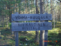
Voima-Kuusela, one of the stops on our tour, is a large excavated row house.


Dwelling structures are indicated by one or more shallow depressions in the ground that are either square or oval shaped. The oval shaped depressions are harder to sight and are older than the more defined square depressions. The depressions were the foundations for pit houses. The hearth is often defined by a spot in the middle where the vegetation is especially lush because of the extra nutrients remaining after burning. Sometimes quartz flakes or pottery shards are visible from disturbance.

Jenn gave her intro to The Thing,
explaining its context as a built up earthen mound, as well as its re-use throughout time. It is an interesting site once used to forge iron and seems to have a double layer of podsol.


The team went to the Kierikki Stone Age Center to have lunch. At the center, they have constructed a row of pit houses as they might have looked 5000 years ago. Some people had lunch inside them around the fire.


In the afternoon Dustin Keeler and Greg Korosec led two survey teams previously designated along the 55th and the 60th contours.
This allows for a systematic search for depressions and pits in the ground, indicating past human disturbance. The goal of these surveys is to cover more ground with more accurate GPS equipment in use.

Michael Wing (the teacher who is part of PolarTREK) who was part of Greg’s team described surveying accurately as follows: “Greg holds a GPS (global positioning system) device that tells us where we are. The rest of us form a line to the right and left of him, each person about twenty steps away from the next. We advance together in a line, keeping our eyes on the ground. We leap across ditches, trip over stumps, slog through wetlands and crash through bushes. Greg moves fast, and you have to keep up! If we see something suggestive of a pit house we call out and Greg comes over to look.”

It is quite the adventure and many of the team members find it a rewarding process even when the results are negative. Greg Korosec’s Survey cleared sites on the 55 meter contour so archeologists looking for Stone Age sites there know not to look there. Dustin Keeler’s Survey of the 60 meter contour came across two sites, one a cluster of depressions and the other a long row of pits.


Day 3: Sunday May 10 2009

EXPLORING OULU

Today was a rest day, some of the undergraduate students chose to explore the tourist aspects of Oulu in the morning. It’s only a short bus ride away or a beautiful 5K walk/bike that takes you through quaint residential areas and forest scenery.

The city was founded in 1605 by King Charles IX of Sweden. Its rapid economic growth is attributed to its exportation of tar and growing university. Fires in 1882 destroyed much of Oulu. Much of the city was re-designed by Carl Ludvig Engel. His designs still dominate the town center to this day.

Some interesting sites in Oulu are the Market Square, Cathedral, Observatory Café, Hupisaaret, the Botanical Gardens, and the Toripolliisi. The observatory café is an observatory tower built on the old foundation of the Oulu castle as part of a The Oulu Marine Institute, but now serves café with a wonderful view of the city. Hupisaaret is a wide park area that offers the opportunity to enjoy nature right in the heart of the city. There are small streams and a few botanical green houses along with salmon runs.

The Toripolliisi is a bronze statue of a large police man that guards the city in the market square. If you drop a letter in the market square it will be stamped with the Market Square Policeman postmark. To learn more about Oulu you can visit www.visitoulu.fi.

Modern art is pleasantly spread throughout downtown. Some are labeled stating their historical significance, others are left up to personal interpretation.

Day 2: Saturday May 9 2009

Day two consisted of Greg Korosec, Eva Hulse, Dustin Keeler, Michael Wing, Dr. Ezra Zubrow, Loretta Sun, and Sarah Billiar going out into the field as well as to the Kierikki Stone Age Center.

It was a great chance for the undergraduates to see for the first time the terrain they would be working in. They went into the field to test the GPS system and run some soil tests to determine how frozen the soil was. Eva is showing Mike and Sarah how to use the auger to run soil samples.

The soil was very soft to walk on and had a sandy texture. Away from the sight at a lower ground level ther was a pretty bog... little did the undergrads know, they would be surveying through it! Eva showed the team lingonberries, which occur everywhere in the forest. Even though they are from last year and slightly fermented, they are still good to eat because they have spent the winter frozen.

The team then drove to The Kierikki Stone Age Center where they ventured onto the roof of the three story log building to set up the GPS system.


The center and the village are located on the banks of the Iijoki River and hold a unique combination of Finnish prehistory, which dates back to 5,000 B.C. To find out more about the Center you can go to http://www.kierikki.fi/sivu/en/kierikkikeskus/.
Day 1: Friday May 8 2009

GATHERING THE RANKS

Our first Day consisted of an introductory meeting, construction of screens, and cataloging of the equipment to be used throughout the project.

During the introductory meeting in the morning we were reminded of the goal of our research, what organizations we would be working with, whom we would be working with, and what was expected of us. The goal of our research is to find insight into the long term human adaptation to climate change in the arctic through excavation and the study of climate models. The organizations we will be working as part of are: The International Polar Year, National Science Foundation, European Science Foundation, and the Finnish Academy of Sciences. Our research team consists of multi-national mix of the brightest professors, graduate, and undergraduate students who are from, the University at Buffalo (USA), McGill University (Canada), University of Oulu (Finland), Villanova University (Spain) and from France. We will also be working with a high school teacher from California, Michael Wing, who is part of PolarTREC . PolarTREC is a program that works with Teachers and Researchers Exploring and Collaborating in the Arctic to encompass learning experiences in both the Arctic and Antarctic. You can find his blog of his time working with us at www.polartrec.com.

During the afternoon we constructed the screens and cataloged equipment. Three screens were constructed. Two fine screens and one coarse. They were put together using only a hand saw, drill, wood, screen, and screws.

The final note of the day was to report to the University at Oulu at 7:30 AM ready to work.

Field School Begins!

SITE UNDER CONSTRUCTION: BACK POSTS ARE COMING ASAP!!! (we promise!)